Salt Trail
The Salt Trail is a route traditionally followed by villagers when taking their produce to the tamu (markets) on the west coast, and returning with salt and other goods. It is still the only access route to the remote villagers in the Park, especially in upper Papar river and Tambunan area.
Updated fees.
| # | Particulars | 18 Years & Above | 17 Years & Below | Remarks |
|---|---|---|---|---|
| 01 | Salt Trail Fee (Malaysian) | RM 50 / person | RM 30 / person | Inclusive of tag and certificate |
| 02 | Salt Trail Fee (International) | RM 100 / person | RM 50 / person | Inclusive of tag and certificate |
| 03 | Insurance | RM 7 / person / day | -- | |
| 06 | Mountain Guide | RM 150.00 / day / 3 persons | -- | |
Major Routes
The are 4 major routes which crosses Crocker Range Park.Inobong-Terian-Buayan-Kionop-Tikolod trail; Tagudon-Kalangaan-Kionop-Tikolod trail; Mile 32 -Timpango Sugud trail; Kuyongan-Longkogungan-Mile32 trail.
But, tourist can now only walk the Inobong-Terian-Buayan-Kionop-Tikolod trail with guides, and stay each night in village homestays.
The total distance of the Inobong-Terian-Buayan-Kionop-Tikolod Trail is 34 km, and hikers are recomended to spend 3 days and 3 nights for the journey. The starting point is in Inobong sub-station which is about an hour drive from Kota Kinabalu via Donggongon road.It is located on the western tip of Crocker Range Park with an altitude of 1400 ft asl. First visitors have to climb up from the station to Mt. Kebambangan (2385 ft asl). The climbing is a bit hard work, but after arriving on the mountain ridge, most part of the trail to Kg. Terian is generally gentle slope. The highest peak is about 2630 ft located on the southern part Mt. Kebambangan which is still surrounded with thick forest. There is a suspension bridge which crosses the Terian river before arriving at Kg. Terian. The distance from the Inobong Sub-station to Kg. Terian is about 10 km with an estimated walking time of about 7 hours.
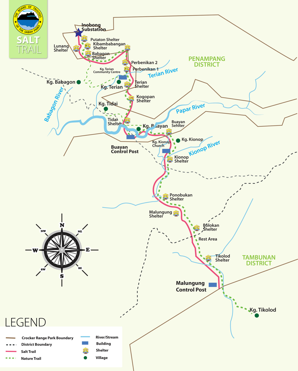
There is no bridge crossing the Papar river from Kg. Buayan to Kg. Kionop, therefore visitors have to cross the river. The best crossing site is the Lower junction of the Papar and the Kionop river from the north to the south side. Crossing the river is a real challenge when the water level is high after rain. The distance from Kg. Buayan to Kg. Kionop is about 5 km and estimated walking time of 3 hours.
The trail follows the Ponobukon river from the Kionop community centre to the tip of the ridge trail. Visitors have to cross the river several times. At the 22.5 km point from the Inobong station, the trail goes up to the main ridge which separates the west coast side and the interior plain area. Most part of the trail in Kionop is gentle but a part of the trail in Tikolod side is steep.The trail meets the Bolotikon river and follows until Kg. Tikolod passing by park boundary. Visitors will pass three shelters before ariving the Bolotikon river. The distance from Kg. Kionop to Kg. Tikolod (Bolotikon) is 13.5 km and estimated walking time of 7 hours.